The Creation of Place in Abandoned Railway Cuts in Windsor: 1/4 Intro

Lee Rodney teaches one of the best courses at the University of Windsor, Border Culture. I took the course in the fall of 2010 and wrote a book: The Creation of Place in Abandoned Railway Cuts in Windsor.

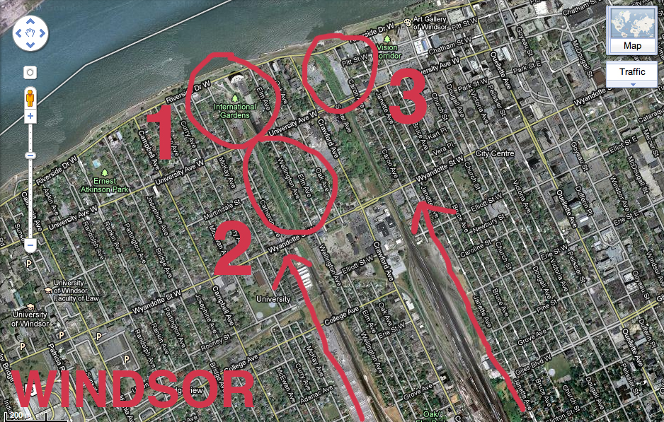
The book serves as documentation and comparative analysis of three specific forgotten spaces in downtown Windsor, Ontario, Canada. Each of these are former sites of railway lines that ran across the Detroit River into Michigan at the height of industrialization in the first quarter of the twentieth century, but are now closed up dead ends and dead zones, unlit at night and undetectable from street view due to their below street level geography.

These spaces have a transient quality, as people exist in them only while passing through, usually as quickly as they can in order to reach a safer location. The contents of this book are based on my own personal experience in and around these spaces as a young adult white female artist, including historical research on the areas as well as references from multiple disciplines including activism, art, urban planning, geography, design, visual culture, gender and feminist studies. The invisible borders embedded within the fabric of these hidden, forgotten underused and misused spaces is examined.

Over the course of the next month, I will be posting chapters of the book with images on a weekly basis. However, I would like to introduce the book by providing some info and context around what I was reading prior to and during the research phase of this project.

So, without further adieu, a few books that informed my book:

Continue reading “The Creation of Place in Abandoned Railway Cuts in Windsor: 1/4 Intro”

Neighbourhood Deterioration and Suburbanism

As I think about where I live, in a subdivision off of dominion road near the Holy Name of Mary Highschool, I immediately think of the current hollowing and cutting into the forest and brush that’s going on to make room for more houses, and more roads. The illumination of this by me is quite ironic however, considering my family and I live in one of these very suburban houses.

It’s obvious this has negative impacts on the wildlife that exists. I see coyotes almost every night trotting just outside the back of the house. During the winter months (such as it is now), we tend to leave dry corn in a wooden box with some apples in the backyard. Some nights I’ve counted 12 dear hanging out just behind my house.

It’s interesting to think of how the literal physical border of this city, via the road and the backs of houses, keep cutting further and further into this small forest landlocked in the middle of the city of Windsor.


This is an older image taken from Google Earth, but I have highlighted one of the sections where they have clear cut the forest and brush. (There’s another large area they have cut on the other side of the bush that I couldn’t fit into the image). The area in yellow today is full of empty streets, and empty  lots with pipes sticking out of the ground.

I guess where I am getting may be partly an environmental awareness and a defense for this landlocked micro-environment, but also an awareness of the suburbanism that has occurred in a city where its downtown core has not been kept up infrastructurally speaking, and has been ‘hollowed out’, so to speak.

Suburban housing development has not only contributed to the hollowing out of the downtown core, but also has been a result of various things such as dependency on economic sectors (auto industry, higher paying jobs, etc…), which has allowed those fortunate enough to buy a house away from the deteriorating core of Windsor itself. The core isn’t getting the economic, social, and infrastructural attention it needs to function in a more cohesive and economically and culturally integrated way (especially considering how the Windsor/Detroit area has had so much potential of economic integration in the past with the integration of the auto industry. But as we know, Detroit is also suffering from neighbourhood deterioration).

I think these conversations also imply other things such as generalizations of classes of people in both cities being a large contributer to the attention (or lack of) payed to certain neighbourhoods, and implies many other cases to think about, like the shallow analysis political leaders of our municipalities provide as a way to talk positively about improving infrastructure of older neighborhoods in city planning.

The irony is, I have only provided a shallow analysis of the problems discussed, which started with me thinking about the geography and situation of my immediate neighbourhood.

This is a ‘before’ picture of the field and forest, which has now been paved with new streets. (I should really provide an ‘after’ picture for effectiveness)


Maybe the ‘make this better’ would be placed in a deteriorating neighborhood, possibly housing or buildings? Although I havn’t chosen a direct area to do this, I hope at the least that it can generate at least one good conversation. I’m still thinking about it!

The Knitted Mile

The Knitted Mile by Robyn Mile. Something interesting about the idea of deliberate and slow labour and what it means as a process. Long-term projects always make me wish for more time.

The Knitted Mile was commissioned as part of an exhibition titled Gestures of Resistance: Craft and The Politics of Slowness (curated by Shannon Stratton and Judith Leeman) that happened in conjunction with the College Art Association 2008 conference in Dallas, TX.

Ninety knitters from around North America contributed pieces of TKM. Photographs of each knitter working on their section were included as part of the piece when it was removed from the road and installed in the gallery, Grey Matter.

TKM also was exhibited at PS.122 as part of the exhibition Yarn Theory, curated by Martha Lewis.

You should also check out some of Robyn’s other huge works.

via Saint Flamingo’s twitter

Theoretical Geography: Bill Bunge and the Quantitative Revolution

Canadian Minorities by Zachary Johnson 2005

Zachary Forest Johnson is (according to his bio page) a cartographer specializing in online maps and information visualizations. He is in the second year of a M.S. program in Cartography and GIS at the U of Wisconsin. In a previous life, he studied Political Science (gaining a BA from the U of Arkansas and a MA from the U of Wisconsin). His other passions include running, politics, typography, and gin and tonics.

Zachary is also the author of the blog indiemaps.com, an interesting blog on contemporary mapping methods using HTML and Java to produce interactive mapping systems and interfaces, various information on historical figures and news. Based on Zachary’s previous education, as outlined above, a certain geo-political undertone can be felt throughout the work; which is a conceptual framework that is at times hard to take at face value (nor should it be) since it is employing abstract data to map something like a countries extent of “freedom” (see Johnson’s “World Freedom Atlas“).

Continue reading “Theoretical Geography: Bill Bunge and the Quantitative Revolution”

Sites of Apology / Sites of Hope: the Map

Not exhaustive, nor complete, this map is a work-in-progress, documenting a community in-transition. For one afternoon in February 2010, we gathered together with a group of community members to create two distinct lists: Sites of Apology and Sites of Hope.

The locations identified as part of these two lists were noted as being places for which we, as a community, might need to apologize to future generations, or places for which we might hold some particular hope of their role in creating a better city for future generations.

Over the following weeks and months, we gradually visited every site on the list to (un)officially recognize it, demarcating it with a large ribbon and saying a few words about its designation. We encourage you to make your own visit to these sites.

Thank you to everyone who contributed to the list and had such an incredible and engaged conversation with us that day. This map is long overdue, but we hope it was worth the wait.

You can download the Sites of Apology / Sites of Hope Map (11″x17″).

Continue reading “Sites of Apology / Sites of Hope: the Map”

Sites of Apology / Sites of Hope

The details: Sunday, February 28, 2010 (1pm) at 362 California Ave, Windsor

As part of the Broken City Lab: Save the City project, and to better understand the city and its rich and failed history, Broken City Lab researchers will host an open community event on Sunday, February 28, 2010 at 1pm to map and invent two distinct community tours—Sites of Apology and Sites of Hope.

Throughout the first part of the event, Broken City Lab will lead community participants in brainstorming the numerous sites deemed to be worthy of apology—these could include failed strip malls, roads without sidewalks, or former auto factories—along with the numerous sites that give community participants hope for the city—these could include an especially great bike trail, sites of architectural significance, or places that can be imagined as being easily improved.

Immediately following the creation of these lists, Broken City Lab will set out to demarcate and officially designate each Site of Apology and Site of Hope. At each site, a short ceremony will be held and community members are welcomed to come along to help recognize each and every site.

A map demarcating each of the designated Sites of Apology and Sites of Hope will be made available online to encourage the ongoing investigation of these sites by community members.

Broken City Lab: Save the City is generously supported by the Ontario Arts Council.

Juxtaposing Windsor’s Auto Plants with Toronto’s Streets

chyrslervstoronto

Consider this required reading: over at Spacing.ca, Shawn Micallef wrote about one his more recent trips to his former hometown, Windsor. Driving down Walker Road again after spending much of his time in Toronto walking, a lot, made him realize just how staggeringly huge these auto plants are, and he questions what we’re all wondering—what will happen when these plants entirely shut down?

Go, read it.

Thanks for passing this along, Rod.

Maya Lin, Topographic Landscapes

an installation shot from Maya Lin's show, Systematic Landscapes at the De Young museum in San Fransisco

Maya Lin has created a number of public art works, memorials, and has increasingly shifted her practice towards studies of landscape, often rendering rivers, geographic relief, and water lines. Interestingly, many of her recent works are made exclusively of reclaimed materials—silver from jewelry, computers, and photographic process, and lumber from sustainably harvested wood.

There’s an interesting, but lengthy, video lecture by Maya Lin on the De Young Gallery website, where she explains a lot of her work and the processes behind it. 

[via]