How Walking Around Your City Can Lead to Something Great

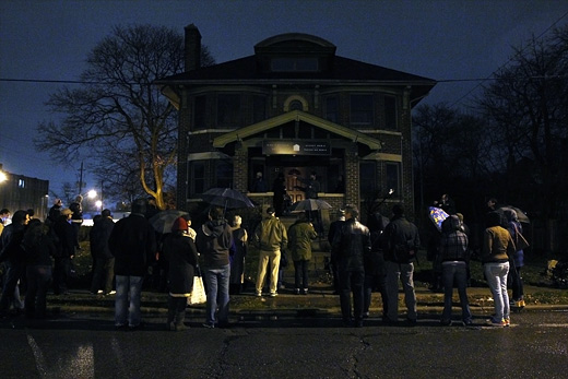
By some estimates (including the CBC), there were 100 people on the walk we took on Tuesday night, in the rain, throughout downtown Windsor.

The attendance alone was inspiring, but what really made the experience so incredible for me was the energy that everyone brought. When we stopped and took a moment to briefly talk about the potential of the Downtown Transit terminal, or the Canderel Building’s huge space, or the properties for lease on Ouellette, the old bingo hall, the House, the city’s storefronts on Pelissier, we got excited together. Things started to feel remotely possible.

It’s that sense of possibility that’s so important right now for our city.

At today’s Artscape Placemaking Workshop at the AGW, we heard some really amazing stories about the work at Artscape has done, the work of Bert and crew at AS220 in Providence, things that started as truly small ideas and have since become cultural movements. It’s all possible, we just need to find the time to walk around a bit more often together.

Then, we need to start getting into some space. And, we should be in a space next to one another, or at least down the block from one another, so we can see one another more often, and we can go for walks and imagine more new things. And then, one day, we’ll look back and say, “remember that walk we took with 90-something other people on that really cold and rainy night…”

Sound good?

P.S. If anyone has any photos or video from the walk, I’d love to see them!

Vancouver [de]Tour Guide 2010

In a rather large-scale collaborative mapping project, artist Althea Thauberger and some of her colleagues are attempting to assemble an alternative tour guide, or rather, a (de)tour guide for visitors to Vancouver while the 2010 Olympic games are underway.

They set it up like this, “For us, it is vital to complicate the sanitized ‘best place on earth’ version of the city VANOC is officially promoting worldwide […] Since Google maps will be the information source of choice to visitors, we are interested in using it as a tool to critically contextualize the city during this high-profile period.”

Exploring the map provides a wide variety of points of interest, some quite interesting, others less so. The map seems to provide the most engaging information when acting as guide to local activist history, with those markers providing some spatial context for what’s happened as a grassroots political level over the last number of years (though it would be interesting to see those in relation to current Olympic-occupied places). However, as a whole, the map is a bit too unfocused to provide any really useful or critical information (and perhaps as a disinformation campaign acting in opposition to the Olympics’ official maps and points of interest, it is most successful).

Conceptually, the goal of the project to reach the front pages of Google when one searches for things to do in Vancouver is quite intriguing — I can imagine that nearly all other information one might come into contact with while in the city during this time will be stamped as an official 2010 Olympics piece of merchandise — it may be that adding suggested routes for specifically-themed tours might be a way for providing some organizational structure for all of this information.

[via an email from Josh, who we met at the Propeller show]