ATTC Calgary Day 3 & 4: the Tales & Timelines of a City

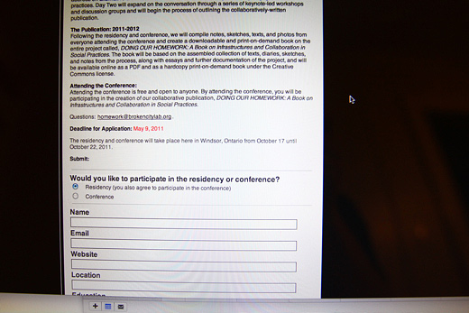
On Day 3 of our ATTC Calgary with Truck Gallery’s CAMPER Urban Discovery project, it rained, and so we planned. We planned and discussed and reviewed some of the answers we had received from our activities on Day 2 — glimpses of the state of Calgary, from a ground-level perspective.

For Day 4, we had to condense our planned events into an single afternoon, collecting answers to a series of fill-in-the-blank statements and eventually creating a CAMPER-wide chalkboard to collect a timeline of Calgary.

Working to understand Calgary through these gestures provides insights to a city in between many things — a military fort and a sprawling urban centre, a longtime home and a temporary situation,the site of the first roadhouse and the place that Tim Hortons amalgamated with a small coffee shop, a celebrated Olympic site and the place of someone’s first concert. All of these experiences, memories, and invented histories create a space for dialogue around the narratives that create the social shape of the city and not only how we interact with it, but how we interact with one another.

Continue reading “ATTC Calgary Day 3 & 4: the Tales & Timelines of a City”

A Look at Process: building for CAFKA & designing for HFBC

We’re playing catchup. Between vacations, short hiatuses, and our summer schedules, we’ve been busy. However, getting back together, working together again on a more regular basis, and starting up on these projects again has been so great and incredibly rewarding. Our to-do list above is a small start to all of the projects we have on the go.

We’re working to finish up our How to Forget the Border Completely research publication (if you want to participate, check out our micro-grant), we’re planning the logistics of Homework (consider attending!), and we’re in the early stages of the final build for CAFKA.

Continue reading “A Look at Process: building for CAFKA & designing for HFBC”

The Creation of Place in Abandoned Railway Cuts in Windsor: 1/4 Intro

Lee Rodney teaches one of the best courses at the University of Windsor, Border Culture. I took the course in the fall of 2010 and wrote a book: The Creation of Place in Abandoned Railway Cuts in Windsor.

The book serves as documentation and comparative analysis of three specific forgotten spaces in downtown Windsor, Ontario, Canada. Each of these are former sites of railway lines that ran across the Detroit River into Michigan at the height of industrialization in the first quarter of the twentieth century, but are now closed up dead ends and dead zones, unlit at night and undetectable from street view due to their below street level geography.

These spaces have a transient quality, as people exist in them only while passing through, usually as quickly as they can in order to reach a safer location. The contents of this book are based on my own personal experience in and around these spaces as a young adult white female artist, including historical research on the areas as well as references from multiple disciplines including activism, art, urban planning, geography, design, visual culture, gender and feminist studies. The invisible borders embedded within the fabric of these hidden, forgotten underused and misused spaces is examined.

Over the course of the next month, I will be posting chapters of the book with images on a weekly basis. However, I would like to introduce the book by providing some info and context around what I was reading prior to and during the research phase of this project.

So, without further adieu, a few books that informed my book:

Continue reading “The Creation of Place in Abandoned Railway Cuts in Windsor: 1/4 Intro”

BCL Report: End of April, 2011 (the Art of Planning & Collaboration)

Over three days this week, we got a lot done. And, as I write this, stuff is still getting done. This is why collaboration is such a valuable model for art practice.

But, it’s not just about getting stuff done, it’s the challenges, the insights, the novel perspectives that can be brought up around a table that push the work forward. With some of us having worked together for nearly three years, we can anticipate one another and move ideas and projects that much further along because there’s a context, there’s a history, there’s a resonating understanding of what we can do together.

Collaboration FTW.

Continue reading “BCL Report: End of April, 2011 (the Art of Planning & Collaboration)”

BCL Report: February 24, 2011 (back to Lebel)

We spent Friday back at Lebel, reminding us of the meetings we used to have a couple years ago when all this was just starting up. Given the size of the school and the resources readily available (like tools, multiple desks, ample light), we split up into smaller groups to tackle some “next steps” for each project on the table.

First though, we watch parts of the interview that Michelle and Rosina did with Stephen Lynn for How to Forget the Border Completely.

Continue reading “BCL Report: February 24, 2011 (back to Lebel)”

Nicole Lavelle’s Lovely Projects: Be Okay + Neighbourhood Flags

Lovely text-based work. It’d be great to randomly run into this!!

As Nicole puts it:

This piece was an experiment in context, engagement and language. Uh, actually, what I mean is: I wanted people to see these phrases in interesting contexts and engage on an emotional level with the words I had chosen. This piece was also about my grandmother dying.

Materials: xerox, colored paper, thumbtacks, paper coffee cups, xerox transfer, manilla envelopes, cellophane bags, staples.

Nicole was also commissioned by GOOD to design a neighbourhood flag — great idea, right?!

Gorgeous work all-around. She’s also designing materials for Open Engagement 2011!!!

Spend some time checking out all her work — book design, typography, you know, making stuff and doing things. Very specific aesthetic choices, but fun reference for our (imaginary) future publications.

This Probably Isn’t Helping: When Gateways Fail

Physical civic improvements are an important step for Windsor. Our gateways, if you’re unfamiliar with the city, are a bit lack-luster at present. Where gateways do exist, the markers are underdeveloped, poorly executed, and are the kind of “this could literally be anywhere” design strategy.

Why do gateways matter? Physically and visually defining space is crucial to understanding where you are, and if gateways are to be the entrance to a city, they need to clearly enunciate where you are, and one might argue that this should denote a certain specificity. Failing at gateways means failing to define a space appropriately and in turn continuing to fail at getting over the “non-place” hump.

Continue reading “This Probably Isn’t Helping: When Gateways Fail”