EC Row Walkway Measurement

High above the traffic on EC Row

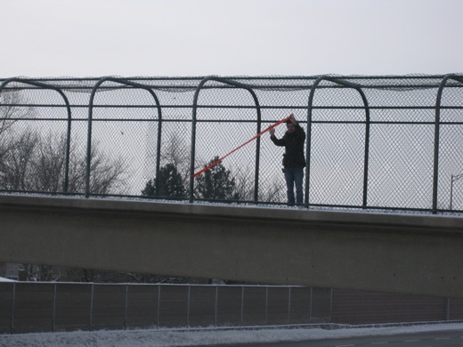
We spent part of Monday afternoon doing a site visit for an upcoming project we’ve been planning for a while. The EC Row Walkway crosses over the 6 lanes of EC Row and is a pretty incredible view. We took some measurements and did a quick visibility test. We were only up there for about fifteen minutes, but there were a lot of people honking, which makes me suspect this walkway is pretty underutilized. Photos after the jump.

Continue reading “EC Row Walkway Measurement”

Office Hours

Office Hours for Broken City Lab at Lebel

It’s that time of the week, Broken City Lab office hours on Tuesday, January 13th, at 7pm, LeBel, room 125. Feel free to drop by to contribute, engage, ask questions, and fix this city. We’ll be discussing some ongoing projects and likely starting to work on an LED sign!

Maya Lin, Topographic Landscapes

an installation shot from Maya Lin's show, Systematic Landscapes at the De Young museum in San Fransisco

Maya Lin has created a number of public art works, memorials, and has increasingly shifted her practice towards studies of landscape, often rendering rivers, geographic relief, and water lines. Interestingly, many of her recent works are made exclusively of reclaimed materials—silver from jewelry, computers, and photographic process, and lumber from sustainably harvested wood.

There’s an interesting, but lengthy, video lecture by Maya Lin on the De Young Gallery website, where she explains a lot of her work and the processes behind it. 

[via]

A Vending Cart of Maps

Making Maps by People, then putting them on a vending cart, project by Katy Asher

With our interest in mapping (and using the fancy technology of Google Maps to try to do so), I thought it might be interesting to post on this project, which is very much not about fancy technology. Katy Asher, a student in Portland’s MFA in Art and Social Practice program, along with Ariana Jacob and Amber Bell, have initiated a project that “aims to make a vending cart of maps made by people from Portland.”

This feels like an intersection of a number of projects we’ve discussed and are also ongoing in the community, and makes me wonder what subjective maps would look like for other Windsorites. Asking for people to map their routes to work, their favourite restaurants, their neighbourhoods would certainly provide an interesting look at the way distances and geography are collapsed or exaggerated and might help to discover some other broken parts of our city and the way it functions (or doesn’t).

Flagging Tape

flagging tape from Canadian Tire

300′ of bright orange flagging tape, $5.97 + tax. It’s fairly thin, but should be really easy to work with. We might have to double it up to make it visible on the fence, that is, double the width of each letter. We should test at Lebel later this week, or maybe on Monday before we go out for a site visit and measurements.

Knitta Please

Knitta's work in France

Knitta formed in 2005 out of frustration of unfinished knitting projects sitting around the house. Instead of trying to finish sweaters and mittens, they decided to go out and bomb the city’s infrastructure (and sometimes garbage) with yarn, starting with their hometown of Houston, Texas and eventually tagging the Great Wall of China. Above you can see a project they did in France. They’ve gotten a lot of mileage out of this project, though things seem to have slowed over the last year.

Anyways, it reminded me of that idea Michelle brought up about dressing up infrastructure in the city for Halloween.