The Creation of Place in Abandoned Railway Cuts in Windsor: 2/4 International Gardens

“One can understand the railroad in engineering terms, as the history of trains and tracks, or in architectural terms, as stations and freight yards, or in urban planning terms, as the right and the wrong side of the tracks, without fully capturing its social history as the production of space.”  — from The Power of Place by Dolores Hayden

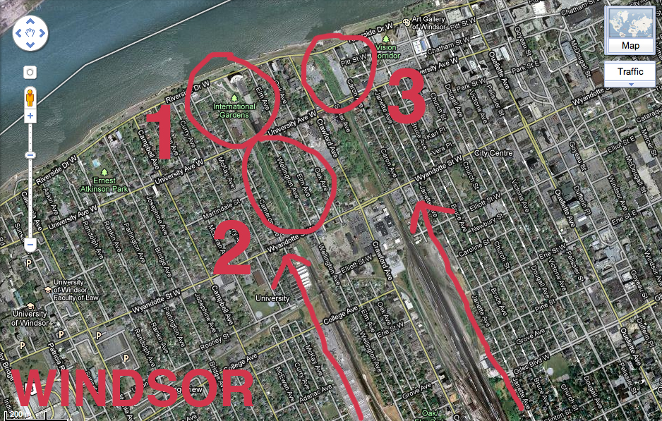
Among the railway cuts examined throughout my research, International Gardens came to be an example of how these types of environments could exist and be somewhat functional when community residents of the surrounding neighbourhood come fourth to maintain, clean up, use and care about them. International Gardens also shows the limits of community engagement without a proper long-term plan, multidisciplinary approaches, or youth integration, as well as the importance of city backing and complications due to lack thereof on initiative such as this.

Continue reading “The Creation of Place in Abandoned Railway Cuts in Windsor: 2/4 International Gardens”

The Creation of Place in Abandoned Railway Cuts in Windsor: 1/4 Intro

Lee Rodney teaches one of the best courses at the University of Windsor, Border Culture. I took the course in the fall of 2010 and wrote a book: The Creation of Place in Abandoned Railway Cuts in Windsor.

The book serves as documentation and comparative analysis of three specific forgotten spaces in downtown Windsor, Ontario, Canada. Each of these are former sites of railway lines that ran across the Detroit River into Michigan at the height of industrialization in the first quarter of the twentieth century, but are now closed up dead ends and dead zones, unlit at night and undetectable from street view due to their below street level geography.

These spaces have a transient quality, as people exist in them only while passing through, usually as quickly as they can in order to reach a safer location. The contents of this book are based on my own personal experience in and around these spaces as a young adult white female artist, including historical research on the areas as well as references from multiple disciplines including activism, art, urban planning, geography, design, visual culture, gender and feminist studies. The invisible borders embedded within the fabric of these hidden, forgotten underused and misused spaces is examined.

Over the course of the next month, I will be posting chapters of the book with images on a weekly basis. However, I would like to introduce the book by providing some info and context around what I was reading prior to and during the research phase of this project.

So, without further adieu, a few books that informed my book:

Continue reading “The Creation of Place in Abandoned Railway Cuts in Windsor: 1/4 Intro”

I made an iPhone App and so can you !!!


For one of my last projects with Sigi Torinus as part of my BFA degree I made an iphone App.

I was able to speed up a usually lengthy process by skipping over the coding portion of creating the app. This was made possible by using Buzztouch, a web-based content management software (CMS) out of Montery California that helps build iPhone and Android apps. Buzztouch provides tools that allow people to create mobile apps and provides a back-end database to support those apps over the long-term. They do both of these things for free, for anyone. The source-code that app owners download for each of their applications is released under an open-source license.

Continue reading “I made an iPhone App and so can you !!!”

Rust Belt to Artist Belt III in Detroit

On Wednesday, April 6th I will be headed across the border to the College for Creative Studies, A. Alfred Taubman Centre for Design Education in Detroit for the Rust Belt to Artist Belt III conference to participate on a panel named Lab Culture: Hands on Think Tanks for Cities, with five other amazing individuals.

Conference participants will explore how economic and community development, entrepreneurialism, and land use in post-industrial Rust Belt cities are being shaped by creative individuals. Attendees will examine best practices for connecting creative practitioners with advanced manufacturers to establish a “Creative Supply Chain.”

Check out the jam-packed schedule and links to panelist and moderator bios here. With over 50 speakers in two days, this is going to be AMAZING.

Hope to see you there!


Two Countries, One Street

With our ongoing How to Forget the Border Completely research project in mind, I’m just about to sit down and watch Two, Countries, One Street on the National Film Board of Canada website.

Filmed in 1955, this short documentary visits the 3 Québec border towns of Rock Island, Stanstead and Beebe, and the Vermont town of Derby Line to see how residents and officials cope with a civic life that is cut down the middle by an international boundary.

It will be good to think about how residents and officials living in Windsor and Detroit might begin to cope with the reality of the border today and in the future, in relation to a similar situation in Québec circa 1955. Mind you, the wide river is what visually distances Windsor and Detroit from each other, and it seems that the communities of Rock Island, Stanstead, Beebe and Derby Line are not separated by a body of water.

It’s only 22 minutes, so check it out!

Detroit Deals

I’ve been thinking about Windsor – Detroit tourism lately for our How to Forget the Border Completely project and since LivingSocial did such a good job advertising to me on facebook, I signed up for weekly Detroit deals and coupons to be e-mailed to me. I’m on week 3 or 4 and so far I’ve considered doing a few of these things…

I also picked up a local tourism magazine from the Windsor Airport. I’ll bring it to show you on Friday, there is an interesting article on things to do in Detroit.

Let’s get over to Detroit soon.

Make This Better: Ripper’s Valley

This is the first in what will be an ongoing series of posts as we temporarily install these letters across the city to generate some conversation and creative thinking around how we can indeed make this (place) better. You can check out the process of making these letters in this archive of posts.

Ripper’s Valley is visible from the Riverfront bike path, which happens to be how I first became interested in it. As an avid cyclist, I very frequently ride down this section of the Riverfront path and quite often see a bustling community of families, a diverse range of cultures, a balanced number of mothers and fathers, grandparents, babysitters and children using the play equipment and nearby benches during the day.

However, within feet of this area is a dead-zone. The entrance to the railway cut is dark, looming, and segregated from the Riverfront Park. In my experience, children venturing toward the entrance are most often called back by their parents and reprimanded to stay within the direct area of the play equipment.

Continue reading “Make This Better: Ripper’s Valley”