Learning About the Emerging Emergencies of North Bay

We’re in North Bay on a residency as we prepare for an exhibition this fall at the White Water Gallery. After spending Monday getting acquainted with the downtown, we ventured further out. Of course, we had to stop at the North Bay arch. Getting a sense of these kinds of structural parts of the city that have, in a way, become shorthand for the entire geography has been helping us to shape the outlines of the exhibition.

Continue reading “Learning About the Emerging Emergencies of North Bay”

iPhone/mobile app dev diagraming

It’s been a long time coming, but I’m getting a lot closer to completing a mobile app. I’ve abandoned objective-c and native app development in favour of what I actually know how to do — namely php, html, css, and a bit of javascript.

Access to phone hardware to make this app do what it needs to do will be accomplished through phonegap.

I’m aiming to try to wrap up a working version of this in the next 10 days or so, baring any major issues I could very likely run into. I’m anxious to share this!!!

Monday Night Drift: Volume 1, South Windsor

Armed with an algorithm from Sara, Michelle, Rosina, and I headed out on a walk on Monday night. We had decided at our last meeting to roam around some South Windsor neighbourhoods — seeing as we rarely get a chance to venture into that part of town — and we were surprised by how much familiarity we encountered.

For starters, we began the walk at the site of one of our first installations (not accidentally), but it was still incredible to be at that same spot nearly three years later.

Rosina and Michelle, bundled.

Along the way, we also took note of a variety of spatial activities — things that demarcate or suggest a curious use of the things around us.

The algorithm Sara gave us guided us through a series of things to find (these are documented at the end of the post), but we also improvised in finding other things. Above, the undulations of the chain link cage.

Michelle demonstrates of they’re made.

And, in an especially great moment, the remainders of that installation.

It was really incredible to take a moment and think about the morning we installed the project.

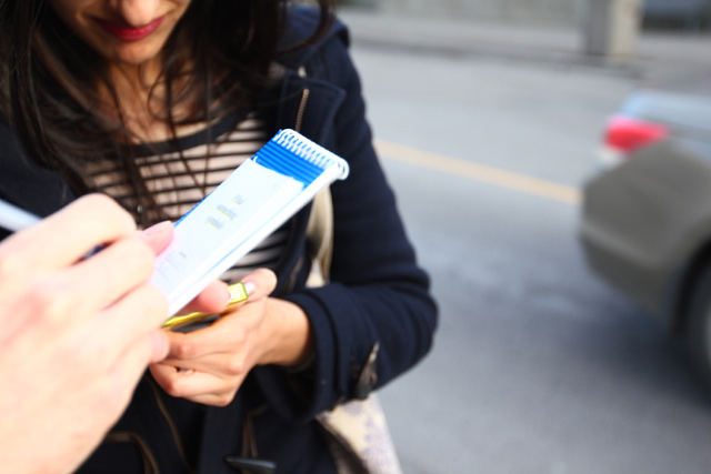
The algorithmic booklet in Rosina’s hands.

After crossing the overpass, Michelle and Rosina look at the neighbourhood.

We begin to document the space — above, a fair representation of the housing stock in the area.

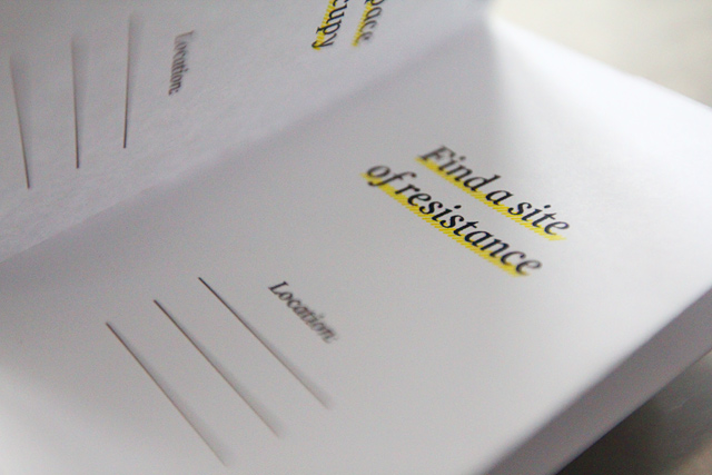
Rosina marks the booklet — the first step, find a site of protest, and we select the installation site of our work.

Shortly after, at the base of the pedestrian ramp for the overpass, we find a portal — the next step. Rosina stakes out the portal, while Michelle heads back up the ramp to send messages.

Michelle sends messages through here.

Rosina listening.

The “portal”, up close. Rosina also reminisces about the area as a site for nearby high school students to congregate. Maybe these used these drainage tubes to send their own messages. Maybe we heard echoes.

We walk around, trying to imagine the construction of these huge spans of free-floating concrete.

We’re amazed in a way.

I was also curious if each light post has its own number, or if this is some kind of other demarcation.

Echoes of covered graffiti, essentially cemented over.

More housing stock, a friend’s place.

In trying to find the next step in our algorithm — a place to change — we all interpreted it as a place to change your clothes (perhaps we were all imagining being on some neighbourhood-wide capture the flag tournament, needing to further camouflage ourselves). We found this large tree.

And then another large tree — these would seem to make the perfect cover.

And then, just to be sure, Michelle suggested something in the streetscape she would like to change. Having biked along this road multiple times, she would love there to be a consistent bike lane.

Far int he other direction, there’s traces of just such a thing.

Then through the school yard at Holy Names.

On the search for something new.

Large tires.

We imagine it must be for giants doing army training.

And then we test ourselves.

Such vast space.

Neighbourhoods border the school.

We find something new in a new neighbourhood.

Then off to find a sanctuary.

At the edge of the parking lot, we wonder what might be in here. At its back corner, there’s some chairs, we consider this someone’s sanctuary.

Around the corner of another building…

…we find some very loose tags, and perhaps something leaking.

And then time.

Then back around to the school. Portables that have long since become permanent fixtures — notice the landscaping.

A break in between portables.

In looking for a place of play, we select an elementary school classroom.

Though we originally marked an interaction with some drivers on their evening commute as the conflict we had to find…

…perhaps this as a site of conflict, with the self ().


Rosina taking notes of our second to last step.

We’re east of Dominion at this point, and we continue to explore, beginning to wind our way back to the start.

A pocket of springtime activity.

A garage.

Traces of big bird via Michelle.

Crossing the second overpass as we head back, a really great detail of seemingly improvised repair.

A path that moves pedestrians between backyards and the EC Row retaining wall.

It zig zags to connect corners of south Windsor streets.

And then, a small view onto the EC Row.

Rosina peaks out.

We couldn’t figure out why this would have been designed into the wall — automotive glory hole. (*update: Thanks to Owen for letting us know its to bring fire hoses through the wall in the event of a big accident)

The view from the wall opening.

The path viewing all the way to Dominion from blocks away — made me wonder about how else to formalize shortcuts through in-between spaces.

Cross walk at Dominion, south of EC Row as we wrap up for the evening.

And then, the algorithm with Rosina’s notation.

Thanks to Sara for getting us lost. I’m looking forward to the next one of these. Maybe next week? Who’s in?

Reflections on Circulations

Last Wednesday I hosted an algorithmic walk around downtown Windsor with some University of Windsor Communications Studies and History grad students. The class, led by Drs. Mike Darroch and Rob Nelson, spent about an hour exploring the city, as per the algorithm, in an area between Park and Pelissier and McDougall and Tuscarora. Groups of three spread out throughout the area and stepped through the algorithm in a different order.

The algorithm connected with some readings the class had done on ideas of circulation. It was based on a series of simple suggestions to look for things that disrupt, capitalize, or imagine forms of circulation in the city. At each step in the algorithm, groups had to take a photograph. Below are some images from the walk.

Find an in-between space.

Find an example of urban improvisation.

Find a transaction.

Find a space to occupy.

Find something symbolic.

Dr. Darroch and some of this students on the walk.

Find  an in-between space.

Find something symbolic.

Find an example of urban improvisation.

Find a transaction.

Find a safe place.

Find the heart of the city.

I think this little 8-page booklet format could work well for our upcoming walks. I know we had talked about theming these walks. Any ideas for the first one on the 13th?


Circulation: an algorithmic walk in downtown Windsor with students from the University of Windsor

On Wednesday, February 1st, I’ll be guiding an algorithmic walk for Dr. Mike Darroch and Dr. Rob Nelson’s history / communication studies grad seminar. I spent part of the afternoon playing around with some ideas to have the instructions, or algorithms, distributed to the class.

We’ve done walks before, they’ve often been quite ambitious and sprawling. Given the two-hour time slot for the class, I’ve tried to keep this one short enough to finish it within an hour. The class did a range of readings on circulation in the city, so I’m hoping that these instructions will help frame some interesting ways to activate some of the larger ideas in the texts.

I started out with something I figured would be just a 1/4 sheet of 8.5″x11″ paper. Each group of students would start at a different number. I want the students to do the same things, just not all at the same time.

So, then I started thinking about those easy to make foldable books.  I can print off one template and just set the fold different ways to offset the starting instruction. I also decided to put a little fill-in-the-page-number-blank  and a few lines to note the location.

Each group will be instructed to take a photo once they find each of these places / things / situations. At the end, maybe we’ll be able to assemble them into a quick slideshow, or map or something to compare notes, so to speak.

We’ve been talking about doing some fairly regular drifts — maybe this is a good model to work from?

ATTC Calgary Day 1: Shortcuts for Urban Resistance & Algorithmic Walks

We’re in Calgary working with Truck Gallery’s CAMPER Urban Discovery project, doing a residency based on our “…and then the city…” (ATTC) research. Developed after a six-month community research project back in Windsor called, Save the City, ATTC was initially realized as two billboards in Windsor and an accompanying publication that looked at the cyclical nature of city narratives — the things that we’re told and the things we tell ourselves about the places we live.

We’re here for 10 days working to develop a practice that can begin to unfold the complexities of Calgary and how the people, architecture, infrastructure, planning policies, and connections shape this city. We’re interested in the largest sense in understanding locality in both its reading and practice, and Calgary is already proving to be a wonderfully curious research site.

If you’re in Calgary, you can catch us at CAMPER by taking a look at our schedule, and if you’re away, you can expect posts everyday on our process.

Continue reading “ATTC Calgary Day 1: Shortcuts for Urban Resistance & Algorithmic Walks”

OPENED/UP: a Walk on November 30th

OPENED UP: A walk through lost, forgotten, vacant, and underused spaces.

For an hour and a half after work on Tuesday, November 30, we’ll be walking around downtown Windsor and getting access to a variety of closed / vacant / underused spaces. Justin Langlois will be guiding it with Tom Lucier and we’re hoping to have a lot of ambitious and excited people out with us. City-owned buildings, privately held storefronts, and cavernous bingo halls are all a part of our route, and you’re invited to join us in imagining a different downtown for our city — one with ample, affordable, and exciting spaces for artists, performers, musicians, and other creative-minded folks. We want to start a real conversation about what it would take to get these spaces filled with people who need them. We want to help give people a reason to be excited about being a practicing artist in this city again. We know that finding space needs to be at the top of that list, and we want to help.

This walk has been organized as part of the Artscape Creative Placemaking workshop being held on December 1st. Artscape, if you’re not already familiar with their work, has brought together and led numerous partners and stakeholders to realize massive studio and live/work retrofits of a variety of underused spaces in Toronto and figured out ways to make spaces for artists not only affordable, but integral to the surrounding neighbourhoods and economies. This walk has been something on our to-do list for a while and Artscape’s workshop just gave us the perfect excuse to do it.

Meet us at Phog Lounge at 5pm sharp. We’ll wind our way through the downtown core and head back to Phog for some food, drinks, and lots of conversation. We really want you to be there, let us know if you have any questions.

You’re Invited: Artist Talks, Conferences, and other upcoming events

There’s a lot of BCL-related events coming up…

First off, I’ll be giving an artist talk at the University of Windsor’s School of Visual Arts tomorrow, November 16 at 12noon. I’ll be discussing Broken City Lab and how I think about collaborative social practice in general. The talk along with follow up questions should run for about an hour — it’s the perfect way to spend your lunch hour. You’re invited!

Details for other events are below, but here are the important parts:

  • November 18th – Windsor + Philosophy
  • November 30th – OPENED UP: A walk through lost, forgotten, vacant, and underused spaces.
  • December 1st – Artscape Placemaking Workshop

Continue reading “You’re Invited: Artist Talks, Conferences, and other upcoming events”

Drifting Around Downtown Windsor: Exploring the City Slowly

We’ve been lucky over the last week or so with some surprisingly agreeable weather. The had humidity lifted and with it, the temperature scaled back considerably. So, it’s been pretty much the best time all summer to do some exploring on foot (and sometimes on bicycle) at a pace that really allows for a different kind of engagement with space.

Now armed with an iPhone 4 for an upcoming project, it’s easier than ever to take pictures on a casual exploration. Something like a dérive, though admittedly a little more aimed at looking for some new potential project spaces than a completely free drift, last night was a perfect time to play with thinking about a variety of spaces, slowly.

These slow explorations really give the time to notice and attempt to unfold the curiosities all around the city. A sign like the one above, “PUBLIC STAIRWELL,” notifies passersby that this space is publicly accessible and annotates something unseen, behind the door. I wonder what else we might be able to annotate with the same authority as this sign that could be suggested as being both public and understood as normally hidden (at least in terms of its use by a public).

Continue reading “Drifting Around Downtown Windsor: Exploring the City Slowly”